- Home
- About Us
- Chapters
- Study Design and Organizational Structure
- Study Management
- Tenders, Bids, and Contracts
- Sample Design
- Questionnaire Design
- Instrument Technical Design
- Translation
- Adaptation
- Pretesting
- Interviewer Recruitment, Selection, and Training
- Data Collection
- Paradata and Other Auxiliary Data
- Data Harmonization
- Data Processing and Statistical Adjustment
- Data Dissemination
- Statistical Analysis
- Survey Quality
- Ethical Considerations
- Resources
- How to Cite
- Help

Appendix A (Additional Information on Creating Area Probability Sampling Frames)
Most of the surveys conducted in countries with limited resources are based on multistage stratified area probability sample designs. Multistage stratified area probability sample designs are quite common across countries. The example shown here is for a two-stage area probability design of HUs where the PSUs are groups of linked United States Census blocks and the SSUs are HUs (both occupied and unoccupied) within the selected blocks.
Creating and selecting primary sampling units (PSUs)
- Create PSUs. PSUs are geographic clusters. In the United States, they are often census enumeration areas, postal codes, or election districts. The size of the geographic clusters should be large enough to contain a population that is heterogeneous with respect to the survey variables of interest, but small enough to realize the travel-related cost efficiencies of clustered sample observations. Good PSUs generally have the following characteristics:
- They possess clearly identifiable boundaries that are stable over a certain time. (Note that all administrative boundaries such as census enumeration areas, election districts, etc., are regularly updated and changed.)
-
- They cover the target population.
-
- They have measures of size for sampling purposes.
- They contain auxiliary data for stratification purposes (see Guideline 3).
- They are large in number.
- They possess clearly identifiable boundaries that are stable over a certain time. (Note that all administrative boundaries such as census enumeration areas, election districts, etc., are regularly updated and changed.)
- Decide on a comprehensive definition of a housing unit.
- What defines an HU and who should be counted as a household member can vary greatly across countries. For comparative surveys, often only a general definition is feasible (e.g., all persons living in private households born before xx/xx/xx in country Y). Be aware that the size of a typical 'private household' also varies among countries. [zotpressInText item="{2265844:KDCB44CJ}" format="%a% (%d%, %p%)"] provide many household definitions used in the European Union.
- A commonly used definition in the United States is "a physical structure intended as a dwelling that has its own entrance separate from other units in the structure and an area where meals may be prepared and served" [zotpressInText item="{2265844:YHPXI3LA}"].
- In 1998, the United Nations defined an HU as “a separate and independent place of abode intended for habitation by a single household, or one not intended for habitation but occupied as living quarters by a household at the time of the census. Thus it may be an occupied or vacant dwelling, an occupied mobile home or improvised HU, or any other place occupied as living quarters by a household at the time of the census. This category thus includes housing of various levels of permanency and acceptability” [zotpressInText item="{2265844:FN9D6JFG}"].
- Determine the appropriate method for listing the HUs (SSUs) within selected PSUs.
- One option is to use a preexisting list of HUs.
- Some 3MC surveys have used satellite technology to help identify and list households, settlements, and habitations, especially those in hard to find areas such as mountainous, riverine, and creek regions [zotpressInText item="{2265844:I9YS4FRL}" etal="Yes" separator="comma"].
- Another option is to send staff to list the HUs in selected PSUs.
- Create maps to help staff efficiently travel to and correctly list all of the HUs within the selected PSUs. (See the section below on maps for creating two stage area probability frames of HUs.)
- Use standardized protocol to consistently enumerate the HUs in selected PSUs in the field.
- If a preexisting list of HUs for the specified PSU is available but the list is believed to be incomplete or if the coverage properties of the list are unknown, the participating country can send staff to the PSU with the pre-existing list and instructions to update and revise the list so that all HUs are included.
- If no pre-existing list is available, or the participating country knows from previous experience that the available list greatly undercovers the HUs in the PSU, have staff enumerate all the HUs in the PSU without the aid of a list.
- If some selected PSUs have lists of HUs that, at least marginally, cover all its HUs and other PSUs do not, a combination of these listing methods can be used.
- One option is to use a preexisting list of HUs.
Creating maps to help staff locate PSUs and enumerating SSUs
- Maps can be created on paper by hand or electronically with a mapping program like ArcGIS [zotpressInText item="{2265844:ZIT45RDW}"] that uses geographic data. Likewise, maps may be distributed on paper or electronically.
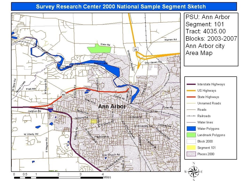
Area Maps
- The purpose of the area map is to show a geographic area large enough to provide context for locating the selected PSUs. Useful area maps typically contain the following features:
- Map Layout: Create area maps so that the top of the map indicates north and the top right corner of the map page displays the name of survey areas, and their associated area numbers.
- Map Legend: Located under the area information, the legend identifies roads, streets, and highways. Water boundaries for creeks, streams, rivers, and lakes can be coded blue. Railroads can be indicated with a cross-hatched line.
- Distance Scale: At the bottom of the map, a scale indicates the range of miles/kilometers the map encompasses.
Example of an area map [zotpressInText item="{2265844:PKVSP48K}"]:
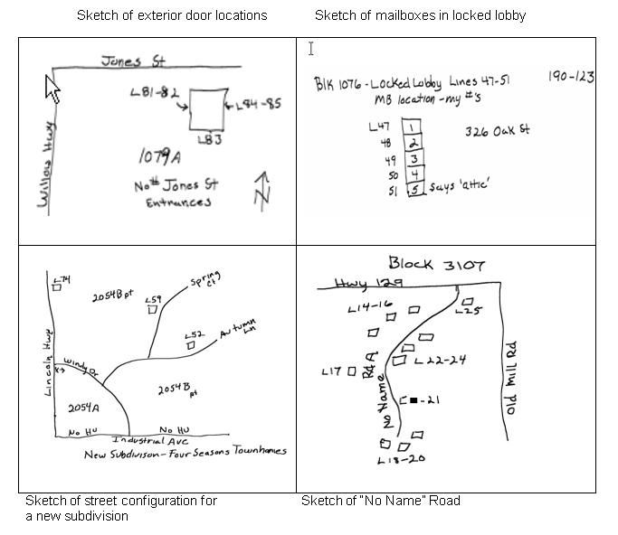
PSU Maps
- The purpose of a PSU map is to update or correct street names, note the line of travel used when listing, and draw landmarks or physical boundaries that will help future interviewers find all the listed HUs in the PSU. Below are detailed instructions for creating PSU Maps:
- Starting X and Directional Arrows: Draw a starting 'X' and directional arrows to assist with the listing assignment. Make an effort to determine a logical starting place for listing each block, like the Northeast corner.
- Once listers have visited the PSU in person, best practice suggests that they update the map to accurately reflect the defined geographical area, including:
- Obtaining information about new streets or housing construction. A visit to the city or county planning office or the engineering or highway department in the area can usually provide the information to accurately record current conditions in the segment area.
- Recording “no household units” along any block face that is clearly devoid of HUs, such as those with parks, vacant fields, parking lots, woods, farm land, or only commercial or industrial structures.
- Recording street names missing from the map(s), drawing in streets, alleys, or cul-de-sacs not shown on the map, and correcting misspelled or incorrect street names. Verify that street names are complete.
Example of a PSU map [zotpressInText item="{2265844:PKVSP48K}"]:
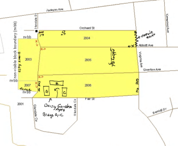
Sketch Maps
- The purpose of a sketch map is to allow listers to supplement the PSU map with their own hand-drawn map when the area and PSU maps provided seem inadequate.
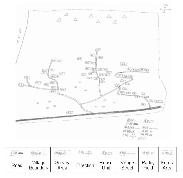
- A few examples of sketch maps are provided below but the list is not all-inclusive [zotpressInText item="{2265844:PKVSP48K}"]. Sketch Map 2 is an example of sketch map used in rural area in China in the China Health and Retirement Longitudinal Study (CHRLS). For more information on the methods for listing in areas without street addresses, rural, or unmapped areas, refer to [zotpressInText item="{2265844:SM4RNMZG}" format="%a% (%d%)"] and [zotpressInText item="{2265844:8349HCB2}" format="%a% (%d%)"].
Sketch Map 1: An example of a sketch map used in a survey in the United States [zotpressInText item="{2265844:PKVSP48K}"].
Sketch Map 2: An example of a sketch map used in the [zotpressInText item="{2265844:5X47H89K}" format="%a% (%d%)"].
Train listers to complete the following tasks prior to beginning the listing procedure—tasks for listing staff to complete prior to enumeration of HUs:
- Contact local authorities. A survey organization can provide listers a letter and a form to deliver to the local police station or some other local authority, alerting them to the survey’s presence in their area. The letter to the local authorities might define the purpose for listing efforts and also give staff a chance to gather information about the local situation. See Data Collection: Face-to-Face Surveys for further discussion.
- Scout the selected areas. Most experienced listers make a complete circuit of selected areas once before beginning listing to get a 'feel' for the area. The purpose is to help find the assigned areas and to confirm or correct boundaries if maps obtained are hard to read.
- It is helpful if listing staff estimate the number of HUs and look for indicators that may explain the discrepancy if it appears that there are twice as many or fewer than half as many HUs as expected by the census count (e.g., new apartment complex or subdivision, HUs which have been demolished in the recent past, or older homes which have been converted to other uses).
Recording the listed HUs
- Listing is an exact record of all HUs, both occupied and unoccupied, that are located in predefined census geographical area boundaries.
- Elements for United States HUs include:
- Block: borough, planned residential area or village number.
- Non-mailable (NM): indicator which is used to identify addresses that cannot receive postal mail because the address is not complete or not unique.
- Line Number (Line_No): the first HU recorded in every listing begins at Line Number 1 with the subsequent HUs encountered being numbered consecutively 2, 3, 4, and so on through all HUs found in the PSU.
- Street Number (Street_No): the street address number should be complete.
- Street Name: check the spelling of street names on sign posts against the street names given on the PSU maps.
- Apartment Number (Apt/Lot): this field should be used for apartment or trailer lot numbers only.
Example of listing format:
| NM | Line_No | Street_No | Street Name | Apt/Lot | Additional Information | |
| 3003 | X | 1 | NO# | FIRST AVE | ||
| 3003 | 2 | 654 | FIRST AVE | |||
| 3003 | X | 3 | 1233 | WILSON ST | ||
| 3003 | X | 4 | 1233 | WILSON ST | Same Street_No as Line_No 3 | |
| 3003 | 5 | 1241 | WILSON ST | |||
| 3004 | X | 6 | NO# | WILLOW HWY |
Additional protocols to help create consistent listings
- Make HU listings consistent across all selected areas. The suggested listing protocols include:
- Begin by listing the lowest numbered block first. Work systematically around the PSU, listing each block in numerical order from lowest to highest block number.
- Start listing HUs for each block beginning at the red starting X and following the directional arrow indicated on the Block Map.
- Look 'over your right shoulder' and record each HU address as it is approached. In other words all listed HUs should be on your right.
- Walk around the block in a clockwise direction, making a complete circuit until reaching the original starting point.
- List only HUs inside the selected (shaded) PSU boundary.
- List empty, boarded up, burned, or abandoned HUs, unless the HU is posted for demolition.
- List on foot whenever possible when you are working in urban and suburban areas.
- Create general rules to deal with the following situations:
- Abandoned, boarded up, burnt out, and vacant HUs.
- Apartment complexes.
- Locked buildings and gated communities.
- New construction.
- Under construction or unfinished construction.
- Check the completed listing.
- Review the listed addresses against the block map for each block in the PSU. Beginning at the starting X and proceeding clockwise around each block, confirm that there are HUs listed for every street in the block or that HUs without a street number have been noted along the proper block face on the PSU map.
- Confirm that there is only one HU per listed line and that listing lines are used only for HUs. Commercial or public buildings such as churches, schools, or businesses should be recorded only in the PSU observations or noted on the map(s).
- Make certain that all HUs without a street number are uniquely described in the additional information column and that their locations are noted on the map by line number.
- Review the PSU observations and make sure they are complete. Confirm that information about locked building, seasonal accessibility, and safety issues are noted in detail.